Unknown's avatar

About caroltracycarr

Writer, Musician, Grandmother, Retired Attorney

Petrified Forest and Painted Desert

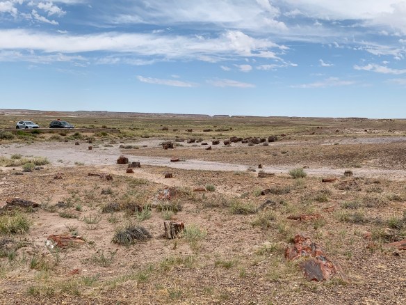
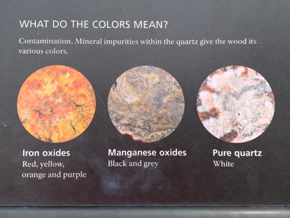
Petrified Forest National Park is one of the best places in the world to see fossils that date back to the Late Triassic Period (approximately 200 million years ago.) While petrified dinosaur remains are relatively widespread through the West, this park is noted for the petrified forest and petrified wood pieces that are scattered throughout the southern portion of the park. Making petrified wood takes a very long time (like millions of years) and the process is detailed below.

A road bisected the park and below are a small sample of the vistas you can easily see from your vehicle. They may look like wood, but they are definitely as hard as stone!

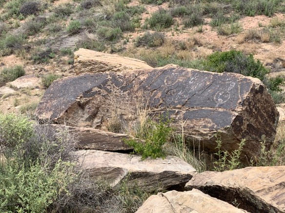
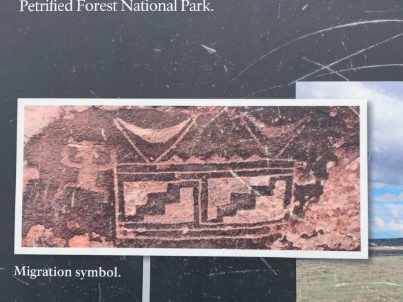
The park also has many petroglyphs, a written record of ancient people who lived in this area, some more than 2000 years old. These were some of the easiest to spot and recognize.

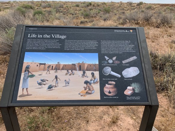
The Puerco Pueblo is another remarkably well-preserved site dating from the 13th century which showed clearly with the many visible remains where the kiva and the main living quarters of the village were located.

Kiva

Painted Desert

We had run out of time by we reached the Painted Desert section of the park, and a quick drive through this section was all we had, but it was a drive with vistas like these below at every turn.

What On Earth Is a VLA?

If you’ve ever wondered where pictures like these come from, it can only be from the radio waves emitted from these objects billions of light years away. So you need something on earth that can translate these radio waves into images, and that is the Very Large Array (VLA.)

The Very Large Array, one of the world’s premier astronomical radio observatories, consists of 27 radio antennas in a Y-shaped configuration on the Plains of San Agustin fifty miles west of Socorro, New Mexico. Each antenna is 25 meters (82 feet) in diameter. The data from the antennas is combined electronically to give the resolution of an antenna 36km (22 miles) across, with the sensitivity of a dish 130 meters (422 feet) in diameter. The entire array and the associated computer constitutes a single telescope.

The array has to be situated in an very isolated place to minimize the amount of radio frequency interference from Earth, and New Mexico is the ideal place. It is located in the central part of the state southwest of Albuquerque and many miles (and cattle guards) away from civilization and still large enough that Route 60 goes right through the middle of the telescope. They are very strict that no electronics are permitted to be turned on (airplane mode doesn’t cut it) and they’re particularly strict that no drones be allowed. Because of these restrictions, taking photos with my iPhone wasn’t possible, so the pictures below are from the VLA website image gallery.

I highly recommend visiting this website for more information about this remarkable, hidden away treasure in our country. In particular, there is an excellent 23 minute video narrated by Jodie Foster giving a great overview of the VLA and its plans for a future Next Generation VLA at https://public.nrao.edu/gallery/beyond-the-visible-vla/. Check it out!

The Difference One Man Can Make — The Billy the Kid Museum in Fort Sumter, NM

No, I don’t mean Billy the Kid, a/k/a William H. Bonney, I mean the Museum’s originator, Ed Sweet. To be blunt, Billy the Kid was a murderer who killed 8 men in the course of his criminal career. He was found guilty twice, sentenced to be executed twice and escaped twice. All before the age of 21 when he himself was gunned down. Not a person I’d want walking the streets of my town. But he was brash, young, notorious and somewhat attractive to the ladies and became the stuff of legends. Several imposters came forward claiming they’d survived; why they’d want to do that when he was a condemned felon with execution awaiting him I’ll never understand. His gravestone was stolen twice (and disappeared for 25 years), and a hundred years after his death he was considered for pardon by the current governor (which was denied.) Movies were made about him, ballads composed. He’s had his moment.

Ed Sweet’s son Don, who has carried on the legacy of his father.

In my opinion, Ed Sweet is the person who made a major difference in the town of Fort Sumter, and his legacy continues long since his death in 1974. Ed Sweet was an avid and open-minded collector of any antique items with a western heritage. After collecting several thousand such items, he and his wife decided to open a small museum to display them. As Billy the Kid had a history with town, they named it The Billy the Kid Museum. The museum now contains at least 60,000 items.

The actual artifacts connected to the Kid are fairly limited, the most notable being the rifle he owned, shown below.

There are dozens of newspaper articles of the era and many Wanted posters. For such a brief life he created a great deal of newsprint.

And of course, there is Billy the Kid’s grave site, located a few miles east of town near the site of Fort Sumter.

Aside from the nominal tip of the hat to Billy the Kid, what impressed me most of Ed Sweet’s legacy is that he brought together artifacts that capture the essence of a time and that easily could have ended up in dusty attics or been thrown in the trash by younger generations, and instead he made sense of them in the context of the history of Fort Sumner. The fort itself was short-lived and a failed attempt by the federal government to control the local Native Americans. But a town grew from these efforts and that museum captures the history of the homes, the local businesses, and, yes, all the criminal activity in a relatively lawless town. It’s a real step back into the Old West.

This is cattle country

Handbells

Spurs

Inkwells

Typewriters and irons

Types of barbed wire

Just a small selection of the many arrow heads found near Fort Sumter

In our many travels, we’ve passed through a few towns where one person or one committee made the affirmative decision to honor its history by gathering from people’s homes, barns or attics those items that capture their town’s history and the people who settled it. These places are special and feel very alive, even if they might be as dusty and worn down by age as the other towns that are on a slow path to becoming a ghost town. Fort Sumner is one of those special ones, primarily because of the efforts of a man like Ed Sweet and his family. Our visit alone left about $100 in the community. In the short time we were there about 30 other people were touring the museum and buying things in a very lovely gift shop. I’m certain the museum is doing much to keep the town’s economy alive. Good job, Ed!

Who Was the Founder of Bartlesville, Oklahoma?

The answer could be Jake Bartles, who owned a mill and a general store on the Caney River and traded with the Cherokee, Osage and Delaware, but it also could have been Carrsville for Nelson Carr who built the gristmill and also built the first school. Or Keelerville or Johnstoneville after George Keeler and William Johnstone who were investors in the 1870’s lucrative fur trade. All were notable citizens who invested their money, time and talents in the area to help found a thriving city that today even boasts of a Frank Lloyd Wright building in its downtown. I was charmed by the city and if I had to live in Oklahoma I’d choose Bartlesville.

Of course, oil had a lot to do with it too. Oklahoma’s commercial oil and gas industry was born in 1897 in Bartlesville Indian Territory when the Nellie Johnstone oil well came in a gusher. (Johnstone’s daughter Nellie dropped the explosive charge that released the oil 1,300 ft into the ground.) That led to a boom that created many oil companies and brought the railroad to town. Today, Conocophillips and Phillips 66 are the main companies in this area.

An important part of the story is the positive collaboration between the native and non-native people. Intermarriage was very common and for some an advantageous way for a non-native to acquire valuable land rights. It appears that some of the tribes became wealthy along with their white colleagues.

The Bartlesville Region Historical Museum contains many artifacts that capture this rich history. Here are some of the highlights.

Above is a replica of the one room schoolhouse that Carr built for his children and the other non-native children in the community. The tribal communities had their own schools that the non-natives were not permitted to attend.

Below is a reproduction of the Carr family parlor.

The Delaware, Osage and Cherokee were an important part of Bartlesville growth. The majority of photographs showed the Native Americans in Western dress, but the respect for tribal customs still remains with many native ceremonies and dances taking place throughout the area.

Delaware artifacts

Delaware tribal dress

The South Union Shakers — Simplicity and Elegance

We’re very familiar with the Shakers. We lived for ten years in Harvard Massachusetts on South Shaker Road, a short distance from the side of a former Shaker community. We also toured the majority of the Shaker communities in the Northeast, always impressed with the simple elegance of their architecture, furniture, and organization and focus of their community. So it was like finding a treasure hidden in the boonies oto come upon a historical market pointing to the former South Union Shaker community. Of about 200 buildings built to support a community of about 350 Shakers, half a dozen remain intact of which 3 open as a museum.

See the USA In Your Chevrolet, or Better Yet, Your Corvette

Our second day on the road brought us to the National Corvette Museum which has one of the finest collections of restored Corvettes in existence. Located in Bowling Green, Kentucky just a quarter mile from the Bowling Green Assembly Plant where Corvettes have been made since 1981, it was opened in 1994.

One of the first cars we viewed was the Corvette model below that Roger once owned, a 1954 Corvette, the second year that’s Corvettes were sold. His was white with gold interior.

Another car he would have welcomed the chance to own was also there,…

In 2014, tragedy struck the Corvette Museum when a sinkhole opened up beneath the front showroom and 8 Corvettes disappeared beneath the ground in a matter of seconds. They have since made this event a highlight of the museum, showing a circulating film of the sinkhole, the news coverage of the event, a simulated experience of walking through the sinkhole (very eery with sound effects and floor rumbling) and details on the the subsequent recovery of the vehicles. (Search for “Corvette Museum Sinkhole” on YouTube where there are several videos capturing the events.} Below are some of the recovered Corvettes and details of the sinkhole.

Thankfully we managed to leave without buying a Corvette (no more room in our garage), but new owners can take delivery of their new vehicles at the museum and also receive a VIP tour of the museum and the plant. It’s well worth seeking out this museum that has an amazing history of its own.

And in case you’re wondering, the Chevrolet name came from its founder, Louis Chevrolet (along with William Crapo Durant.) Chevrolet was also integrally involved with the history of automobile racing, and Corvettes continue to be very competitive in international racing.

Our Itinerary (So You Can Worry About Us in the Right Place)

When Roger creates an itinerary, it’s fairly certain that we’ll be where we say we’ll be. So our plans for ultimate destination and the highlights of each day are as follows:

June 4 — Ashland , KY (I-64)

June 5 — Calvert City, KY (National Corvette Museum)

June 6 — Neosha, MO (US Rte. 20)

June 7 — Woodward, OK  (US Rte. 20)

June 8 –Fort Sumner, NM (Billy the Kid Museum)

June 9 — Springerville, NM  (Very Large Array)

June 10 — Flagstaff, NM (Petrified Forest, Meteor Crater Natural Landmark, Walnut Canyon National Monument)

June 11 — Williams, AZ (Sunset Crater Volcano National Monument, Grand Canyon South Rim)

June 12 — Bakersfield, CA (I-40)

June 13 — Fresno CA (Sequoia National Park)

June 14 — San Rafael, CA (Our destination!)

June 15-16 (Sightseeing in and around San Rafael)

June 17 — Ridgecrest, CA (Rte. 120)

June 18 –Mesquite, NV (Death Valley National Park, Dante’s View)

June 19 — Page, AZ (Zion National Park, Grand Canyon North Rim)

June 20 — Gallup, NM (Canyon de Chelly National Monument)

June 21 — Tucumcari, NM (Petroglyph National Monument)

June 22 — Oklahoma City, OK

June 23 — North Little Rock, AK (Arkansas Capital, Clinton Presidential Library and Museum)

June 24 — Dickson, TN (National Civil Rights Museum)

June 25 — Blountsville, TN

June 26 — Home!!!


California, Here We Come

america architecture bay boat

2019’s summer travels will take us cross-country again, this time to San Francisco to visit family and connect three generations of the Carr family for a three-day celebration of Father’s Day Weekend. This time we’re taking a southern route, which will take us to the National Corvette Museum in Kentucky, the North and South Rims of the Grand Canyon, Petrified Forest, Sequoia National Park, and the Billy the Kidd Museum in New Mexico with many mountains, valleys (like Death Valley) and plains along the way. We welcome you to come along with us. If I can get an internet connection, I’ll post pictures as often as possible.

Chihuly, Glass Wizard

Even though the Chilhuly Garden and Glass in Seattle Center at the base of the Space Needle provides a lot of information about the hard work and the collaborative process behind Chihuly’s remarkable glass creations, there is still an element of magic in each of his pieces that is uniquely Chihuly. His skill in his medium, his incredible use of color, and the imaginative and fantastic portrayal of simple things like fish, flowers, and amorphous shapes are all elements of the stunning work he does. In eight galleries, three drawing walls, and magical garden, his pieces amaze, amuse, and sometimes awe. Below are just a few examples of Chihuly’s works that were part of our Saturday in Seattle:


Driving Through the Bottom of a Floodplain

Thursday morning, July 24, found us camped on the banks of the Snake River surrounded by the hills of Eastern Washington, one of the most scenic campsites we’ve ever stayed at.

View from our Capsite at Lyon’s Ferry on the Snake River

Our destination was Seattle, to spend a long weekend with family, but first we wanted to see Palouse Falls, just a few miles away. The Palouse Falls are over 1,000 feet high and, along with the canyons beyond it, are part of the channeled scablands formed by the Great Missoula Flood, a series of glacial freezes and thaws that periodically flooded the plains of Montana, Idaho, Washington and Oregon covering the land with water that left its mark on the canyon walls. A map of this flooding shows where Palouse Falls sits in relation to the flooding.

Palouse Falls, formed by the Palouse River

Canyon created by Palouse River below the Falls

As we were headed for Seattle, much of our drive took us through land that had at one time been covered by water, and when viewed from that perspective, much of the land formations and valleys carved with ridges and channels (former sandbars?) make sense. The picture below (thank you, Wikipedia!) illustrates this far better than any of mine.